GRWC Restoration Program
Many different factors can affect the health of watershed habitat. No single factor is responsible, but as far as salmonid populations are concerned, time is of the essence to provide viable habitat. The focus must be on remediating the major impacts we can quantify and have the tools to fix.
Sediment Solutions For the Gualala
 Erosion control and erosion prevention work is the first and perhaps the most important step to protecting and restoring watersheds and their anadromous fish populations.
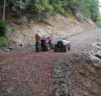
Unlike many watershed improvement activities, erosion prevention and "storm-proofing" has an immediate benefit to the streams and the aquatic habitat of the basin. Roads are a major source of erosion and sedimentation on most managed forest and ranch lands (Weaver and Hagans, 1997).
 For restoration the GRWC prioritizes planning watershed and their road networks based on sediment source analysis, road densities, roads proximate to streams, in-stream habitat and land use.
We assist landowners with planning, funding and the implementation of BMPs to upgrade timber, rural subdivision, and ranch roads based on protocols developed by Pacific Watershed Associates, Inc. and the Department of Fish and Game, Habitat Restoration Manual, Chapter X.
Working Tools for Working Lands
Developing straight forward tools for use in the field increases participation in BMPs and watershed restoration. The GRWC offers a number of tools and resources for all scales of watershed assessment and planning related to sediment source evaluation and remediation.
- Watershed-wide road inventory database linked to GIS network.
- Watershed-wide monitoring program inventory database linked to GIS network.
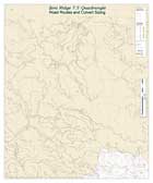
- Watershed-wide integrated working maps linked to databases for assessment and monitoring road systems within the watershed. The grid module is used to evaluate sub-watershed size then uses a hydrologic model to color streams based on the culvert size needed to withstand a 100 year flood. Maps can be used in the field for a rapid assessment of correct culvert sizing to withstand a 100 year flood. Maps can also be tailored in a number of different ways designating individual parcels, planning watersheds, or USGS 7.5' Quadrangles.
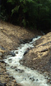
Large Wood In the Stream Program
 Large wood is the most effective tool to increase pool scour and formation, provide cover and shelter habitat, develop areas of reduced winter flow velocity, and promote substrate metering. All these factors are considered limiting to salmonids in all tributaries of the Gualala.
 Over the past decade data have demonstrated that increasing large wood loading levels has an immediate and long term effect on remediating a majority of the limiting factors salmonids encounter in the watershed.
Increased pool formation is generated within the first year in stream reaches where wood is artificially loaded.
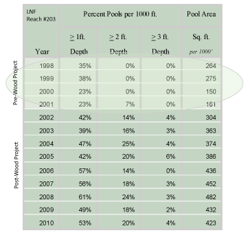
At Site #203 on the Little North Fork, a LWD reference reach, GRWC has compiled four (4) years of pre-project data and nine (9) years of post-project data (see chart above). The post-project data clearly show pool formation caused by LWD loading and a more than twofold increase in primary pools (over 2 ft.) within the reach.
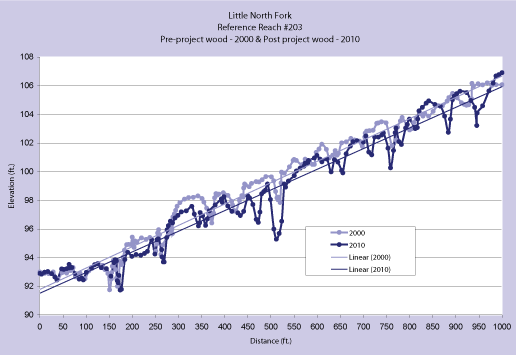
The chart below compares a thalweg profile for 2000, pre-wood project and a thalweg profile for 2010, post-wood project at Little North Fork Site 203. The profiles represent a visual and statistical demonstration of the increased pool formation post project.
Related Info
![]()
Handbook for Forest and Ranch Roads
Hagans and Weaver, 1994![]()
Habitat Restoration Manual
CDFG
(Flosi, et al. 1991)
![]()
Pacific Watersheds Associates
![]()
A Little Large Wood Humor![]()
Dead Wood Dynamics in Stream Ecosystems
Naiman, et al. 2002![]()
Pool Spacing in Forest Channels
Montgomery, et al. 1995
![]()
Large Woody Debris in Forested Streams in the
Pacific Northwest: Past, Present, and Future
Bisson, et al. 1987
![]()
Gualala River Watershed
Road and Culvert
7.5' Quadrangle Maps
Watershed Quadrangle Index Annapolis
 Big Foot Mtn.
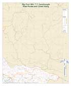 Fort Ross
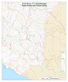 Gualala
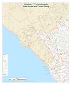 Gube Mountain
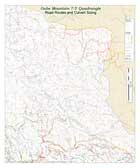 McGuire Ridge
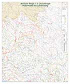 Plantation
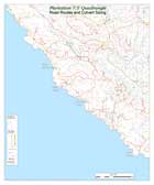 Stewarts Point
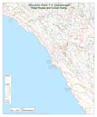 Tombs Creek
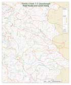 Zeni Ridge