North Fork Gualala
Overview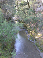
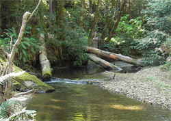
The 42 square mile North Fork Super Planning Watershed (SPW) drains 16% of the watershed through 127 miles of fish bearing streams.
Major streams in the watershed include the North Fork Gualala main stem, the Little North Fork, Doty Creek, Robinson Creek West, Dry Creek, Stewart Creek, Robinson Creek East, Bear Creek and Billings Creek.
The San Andreas rift zone underlies the first mile of the lower North Fork mainstem and the Little North Fork. The Tombs Creek fault zone intersects the upper reaches of Billings Creek causing deflected stream channels along Billings Creek and Robinson Creek East.
At the base of the Billings Creek Planning Watershed (PWS) along the Tombs Creek fault, dense conifer stands give way to prairie grasslands and oak woodland although mixed conifer hardwood stands dominant the north slopes. Approximately 17% of the North Fork Subbasin consists of prairie grasslands/oak woodland, these areas are primarily concentrated in the Billings Creek PW.
Current Condition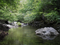
The habitat within the North Fork basin provides our best refugia for salmonids and is the last remaining area of the watershed to have documented populations of California Central Coast Coho.
The North Fork, specifically Doty, Robinson and the Stewart Creek Planning Watersheds (PW), is designated as the Core Area within the Gualala for restoration by both the California Department of Fish and Game (CDF&G) and the National Marine Fisheries Service (NOAA).
Extensive focus from the GRWC over the past decade has included in-stream assessment, monitoring and both upslope and in-stream restoration.
Monitoring Findings
Between 1998 and 2011, forty-two (42) surveys were completed at ten (10) reaches in the North Fork. The reaches are located on the mainstem of North Fork Gualala (473, 204, 691), and the Little North Fork (404, 203), Robinson Creek West (207), Dry Creek (211, 212) and Robinson East (692, 697). Sites 203 on the Little North Fork and 211 on Dry Creek are reference reaches and are monitored every year.
 Surveys show that stream thalwegs are lowering throughout the North Fork basin, on average by 0.40 feet. Only one monitoring reach, the lower Dry Creek reach 211, is showing an increase in channel bed elevation.
This site has aggraded 0.56 ft. since 2006. Whereas, site 212 the upper reach on Dry Creek, has lowered by 0.40 ft. After review, and finding no apparent landslides or unusual sediment discharge between the two reaches, it appears that this may signal a passage of channel bed aggradations through the lower reach of Dry Creek.
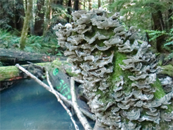
Pool development has been occurring in most reaches in the North Fork SPW. Little North Fork 203 has the most dramatic increase in the number and depths of pools due to wood loading through the GRWC Wood In the Stream Program.
Restoration
The sub-watershed contains the highest priority areas for restoration, specifically Doty, Robinson and the Stewart Creek PWs.
 Starting at the Planning Watershed scale, with the highest road density planning watershed and the best refugia, the GRWC in partnership with Sotoyome Resource Conservation District, the California Department of Fish and Game and the landowner, Gualala Redwoods, Inc. has completed the restoration of all the high and medium priority timber and ranch roads within the Doty Creek Watershed.
This year our focus is on the Robinson Creek and Stewart Creek Planning Watersheds. By building upon existing landowner restoration efforts we will complete the restoration of all high and medium priority roads within the Robinson Creek PW and begin the assessment of roads within the Stewart Creek PW.
With funding assistance from the CA Department of Fish and Game, and through the Large Wood In the Stream Program a total of 330 logs with a volume level of 40,564 cubic feet have been placed in Little North Fork, Doty Creek, Robinson Creek, Upper Dry Creek and the North Fork.
Land use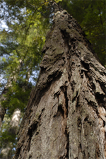
The subbasin has the longest span of past land use practices in the watershed. Sixty-eight percent (68%) of the North Fork is owned by industrial timber companies.
In the past twenty years, in excess of 50% of the Doty, Robinson and Stewart Creek planning watersheds have been harvested.
In the upper reaches of the watershed, primarily the Billings Creek PW where the landscape changes to a Douglas fir and Oak woodland environment, there is a small amount of rural residential and vineyard development but the primary land use is ranching.
The North Gualala Water Company diverts water from the North Fork mainstem above the confluence with the Little North Fork. The diversion supplies water to town of Gualala from two well sites located in the flood plain on the North side of the river.
| Planning Watershed | Acres | Stream Miles | Road Miles | Roads per Sq. Mile | Temperature Sites | Monitoring Reaches Proposed | Monitoring Reaches Installed |
|---|---|---|---|---|---|---|---|
| Doty Creek |
4628 | 15 | 60* | 8.4 | 9 | 4 | 2 |
| Robinson Creek |
8792 | 46 | 93** | 6.8 | 20 | 8 | 5 |
| Stewart Creek |
6585 | 27 | 78 | 7.7 | 4 | 2 | 1 |
| Billings Creek |
10650 | 39 | 79 | 4.8 | 4 | 5 | 2 |
| NF Total | 30654 | 127 | 310 | 6.6 | 37 | 19 | 10 |
*All high and medium priority roads are upgraded. Funding provided by the landowner, Gualala Redwoods, Inc. and the California Department of Fish and Game's Fisheries Restoration Grant Program.
**Funding is secured for upgrading high and medium priority roads. Work is slated to be completed by the fall of 2012.
Geologic and Geomorphic Features Related to Landsliding Map
California Geologic Service
2003
(10.6 MB)
Related Info
![]()
North Fork Flow Gauge
![]()
North Fork SPW Assessment
NCWAP 2003
(5 MB)
![]()
North Fork HSA Monitoring Site Data
(PDF)![]()
North Fork HSA Monitoring Site Map
(PDF)![]()